
Flight
Driving
Salmo to Ottawa
Updated: 31 May 2026
Traveling from Salmo to Ottawa covers approximately 4,400 km across the Canadian landscape. The most efficient route involves driving 30 minutes to Castlegar (YCG) and flying to Ottawa (YOW) with connections in Vancouver or Calgary. Driving the entire distance takes roughly 45 hours of active road time via the Trans-Canada Highway. You will traverse the Rocky Mountains, the Prairies, and the Canadian Shield. This journey offers a dramatic transition from alpine terrain to the urban center of the nation's capital.
Total Distance: 4,400 km driving distance; 3,350 km straight-line air distance.
Fastest Way
Flight from Castlegar (YCG) to Ottawa (YOW) takes approximately 8 hours including layovers.
Cheapest Way
Driving is often cheaper for groups of three or more, costing roughly 600 CAD in fuel.
Compare Salmo to Ottawa Routes
|
Connecting
|
Direct
|
|
|---|---|---|
| Duration | 8 hours | 48 hours |
| Avg Price | 500-900 CAD | 600-1000 CAD in fuel |
| Operator | Air Canada | Personal Vehicle |
| Route | YCG to YVR/YYC to YOW | Highway 3 to Highway 1 |
| Tip | Book your flight from West Kootenay Regional Airport to avoid the long drive to Kelowna. | Ensure your vehicle is equipped with winter tires if traveling between October and April. |
Travel Tips
-
Airport ChoiceUse West Kootenay Regional Airport (YCG) to save 3 hours of driving compared to Kelowna (YLW).
-
Time ZonesRemember you will cross three time zones moving from Pacific to Eastern Time.
-
Highway 3The Crowsnest Highway is scenic but winding; drive cautiously during heavy rain or snow.
-
AccommodationBook hotels in major hubs like Regina or Winnipeg if driving to break up the long journey.
-
ConnectivityCell service is reliable on major highways but spotty in remote stretches of Northern Ontario.
Safety Tips
-
WildlifeWatch for moose and deer on highways, especially during dawn and dusk.
-
Winter DrivingCarry emergency supplies including blankets, water, and a shovel in your trunk.
-
Road ConditionsCheck DriveBC and 511 Ontario websites before departing for real-time closures.
-
FatigueLimit driving to 8 hours per day to maintain alertness on long stretches.
People Also Ask
-
Is there a train from Salmo to Ottawa?No, there is no passenger rail service in Salmo; you must drive to a major hub like Vancouver to access VIA Rail.
-
How long is the drive?The drive takes approximately 45 to 50 hours of actual driving time.
-
What is the best airport near Salmo?West Kootenay Regional Airport (YCG) in Castlegar is the closest.
-
Do I need a passport?No, domestic travel within Canada does not require a passport, but government-issued photo ID is mandatory for flights.
-
Are there buses?Inter-city bus service is limited in the Kootenays; private shuttles are more common.
Quick Info
- From Salmo, British Columbia, Canada
- To Ottawa, Ontario, Canada
-
Modes
Best Time to Travel
September to October for fall foliage and stable weather conditions.
Things to Do in Ottawa
1
Parliament Hill
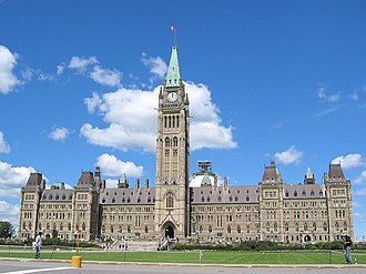
Visit the seat of Canada's federal government in Ottawa. Take a guided tour of the Centre Block and Peace Tower.
2
Rideau Canal
Walk along this UNESCO World Heritage site. In winter, it transforms into the world's largest skating rink.
3
Canadian Museum of History
Located just across the river in Gatineau, it houses the world's largest indoor collection of totem poles.
4
ByWard Market
Explore this historic district filled with artisan shops, farmers' markets, and diverse culinary options.
Tags
Salmo to Ottawa travel
flights from Castlegar to Ottawa
driving Salmo to Ottawa
Canada cross-country travel
best way to reach Ottawa from BC
traveling across Canada
Salmo transport guide
Ottawa transit tips


